


A Brewery in the Middle of Nowhere
- Alain
- May 8, 2019
- 6 min read
Updated: May 14, 2019

May 7th, my legs are starting to feel like Jello, so I have a nice 100 km loop with minimal climbing planned. Minimal in this area is usually <1000 meters. The plan is to drive north of here for 10-15 minutes to avoid riding on Williamson road, which by now, is the equivalent to the Pacific Coast Hwy in Malibu. It's got fast moving cars, the shoulder here is worse than the PCH and it's always got tons of N-S wind. The weather is uncertain, and when I mean uncertain, I don't mean Ottawa uncertainty. The forecast changes by the hour. It's cold with possibility of rain (40%) from noon to 1, so we pack up all the cold weather gear along with the bikes, and we head north. The plan was to park in a fancy neighborhood that has no houses. Roads are built up, paved, and remain vacant until another zillionaire shows up with money to build a mansion. As we get to that area, we realize that it's gated, 'cause many people seem to like to live behind gates and fences here. So we have to find a new parking spot. Leaving a car on the side of the street in the middle of nowhere is a great way of returning to it jacked up on blocks, stripped of everything. Of course, there's no cell reception here either so we're just driving around like tourists. Luckily, we find a firestation, where the fire chief Ed greets me. He gladly lets us park in the firestation parking lot.
Bikes are assembled, and we're still debating on what clothes to bring. As you can see, it's now sunny and really hot, so I candidly decide to leave the rain jacket behind because it would be too bulky in my rear pocket. Wait to see how that decision pays off. We head down a short stretch of the Prescott PCH to then turn onto Fair Oaks road. Again, it's nice and paved but will be leading us to some awesome valley gravel, as in a valley in between mountains, roads with short rollers vs long drags.
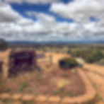
The views from the valley are spectacular. You can see behind Siavash, Granite Mountain. Those are the mountains right across from our house. The skies also provide a dramatic effect to the panoramas...it's an amazing day. From this point on, the plan is to continue to Forest Service road 21, take a short Forest Trail and pop up on Calle Diamante (or so says Strava). An easy left onto FS 21 brings us onto some super sweet gravel roads. Short rollers that are easy to pedal up and let us easily glide down the other side....this is going to be the perfect recovery ride. Note that it's around 11am by now...we left a little later this morning to avoid the morning showers...remember this for later.


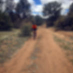
The scenery is breath-taking (I saw that Seinfeld episode tonight). Energy expended...minimal, temperature, warm and sunny. We continue on for another 7k or so before we are set to make a sharp left turn onto a forest trail. We go right by it. We turn around and see that it's fenced (with one of those movable fences to allow cows to go by). The fence has a government sign on it so I know we're not trespassing. This ride is becoming even cooler. We get to ride gravel trails. So we open the gate, cross and then close the gate. Perfect, now let's follow the map and keep going. 5 minutes go by and things are great. This is a trail but it's not too rough. There are some sandy parts, a few wash outs (don't know where the water is 'cause it's soooo dry) but generally, not bad.
3 km's in, and the gps tells me to go left....I'm not sure where that goes 'cause there really isn't a trail there. I tap into my inner Daniel Boone and find what looks like a trail. So we head in that direction. A few minutes later, we actually find a trail, but it's rough. It's also been trampled by either a horse or a lone cow. This is not a gravel bike trail, but a MTB trail. We keep plowing forward until we hit a fence...wtf man...Strava said it was a road. Apparently, Strava encourages trespassing 'cause there's a "POSTED" sign, which pretty much means, stay out, you've been warned, I will shoot. That sucks 'cause only another 2.4 km more and we'd be on Calle Diamante. After a minute of analyzing the situation, we decide to back track and head back up FS21 to Tanto road, which was where we'd end up popping out anyways. Plan B is now in effect. Back on FS21, we retrace our route back to Tanto road. Tanto is a dream to ride. Again, it's nice, smooth and full of easy rollers. It's amazing. A man, Siavash just realizes that he lost his GoPro. It must’ve fallen while riding the Forest trails. He’s pissed. We keep going, we’ll retrace our steps another day in the hopes of finding it.


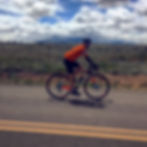
Now however, the clouds on the horizon are starting to be a lot more ominous, and the temperature is dropping. At this point, I'm starting to question leaving my rain jacket in the car. Why didn't I bring it, it's light and it's waterproof...and warm. At the same time, Siavash (#TekneCC) realizes that we won't be eating at noon, and that could be a problem, 'cause just like Obelix (a cartoon from when I was a kid), his stomach tells him it's time to eat, and, other than gels, homemade snacks and water, there isn't really any food for hours, let alone cell service to UberEats something in. Plan B might have to change into Plan C. Here's a gratuitous bike down on the road picture, adds nothing to the story

The current planned route had us go down Tanto, veer right onto another Forest Service Road (to add distance) and back onto Tanto. We decided to follow that plan but just like on our previous attempt, this service road ended at a fence. We turned around and kept going down Tanto. To our surprise, we showed up at a brewery...how cool, in the middle of a valley, a brewery. Unfortunately, they're only opened Sat/Sun. We rolled up to it anyways to check it out. The door was open as I'm assuming the owner was working, but he wasn't there (for some reason, I don't have a picture of the outside of the brewery (#BarnStarBrewery)


Alright, no beer or food here, we keep on going. We only have 5 more kilometers to go before we can enact Plan C, which is to not do a gravel route back to the car but climb Iron Springs Road up and down to Prescott and take the Prescott PCH back. Also, at this point in time, the blue of the sky has been replaced by the black of angry clouds. Warmth of the radioactive fireball in the sky has also been replaced by the frigid Ottawaesque coolness. Did I mention I'm wearing a short sleeve jersey only. At this point, we're 2 minutes from plan C when we crossed the Santa Fe railroad.
The Atchison, Topeka and Santa Fe Railway (reporting mark ATSF), often referred to as the Santa Fe or AT&SF, was one of the larger railroads in the United States. Chartered in February 1859, the railroad reached the Kansas-Colorado border in 1873 and Pueblo, Colorado, in 1876. (exert from Wikepedia
There's so much history here, it's really cool.

From here, we decided to follow plan C, which was to ride up Iron Springs, a 14 km climb (from where we intersect it) with a modest incline, where didn't make it too annoying for my tired legs, and go for some lunch in Prescott. Once we reached the top, the temperature had dropped to 14C, which isn't too bad but the following high speed descent would make it a tad colder. We bomb down the mountain side. This is a catch 22 situation, where, if I coast, I freeze, if I pedal, I warm up but go faster, so I freeze. This descent was a mix of both as I couldn't figure out what was worse. By the end of the descent, we hit a red light where we had to make a decision....keep going down the rest of the way and grab lunch, or turn left on the Prescott PCH and go home. We chose to go home...plan D. The way back consists of 3 short climbs but with an overall descent into Williamson. 2 minutes in, of course, the rain starts to fall. Annoyed by the fact that I didn't have anything to cover up with, I decide that the only way to end this is to pedal faster. We hammered home. As we got there, we were pretty wet but not completely frozen. That started happening a few minutes later as the house keys were still in the car at the fire station. Luckily, our AirBnB host was most awesome and gave us a spare key, and a ride to get our car back. All and all, still an awesome ride. Slightly shorter and slightly more climbing than Plan A but close enough considering the on-the-fly changes

